Plat Maps Showing Family Farmland Since 1886
Ove Syverson: 1840-1882
Ole Syverson: 1873-1933
Peder Peterson: 1815-1880
Paul Peterson: 1867-1941
When my mother died a few years ago, I, along with my
brother, inherited farmland in Brown County, Minnesota. Recently, my brother
sent me the latest plat maps of Linden and Lake Hanska Townships where my land
lies, showing me as the owner. This made me curious about historic plat maps. I
wanted to trace the ownership of those lands over the years, seeing where my
ancestors first lived and homesteaded, and what farms they eventually settled
on, and when those farms changed hands. I knew there were maps from the 1940s,
but was pleased to discover maps from 1905 and 1914, with the most exciting
discovery a plat map from 1886!
Here is the present-day plat map, showing my two parcels,
one near Nora Unitarian Church just west of Linden Lake, and one southeast of
our family’s home place, which my brother owns.


To go back to the very beginning, here are the 1886 plat
maps for Lake Hanska and Linden Townships. To provide some background, my
paternal great-grandparents, Peder and Anna Pederson Joramo, had immigrated
from Norway in 1870. They moved around a bit before settling along the border
of Lake Hanska and Linden Townships. They were residents by 1875, but probably
arrived a couple of years earlier. Tragically, Peder was killed in a farm
accident involving a horse in 1880, so by the time this plat map was made,
Peder’s eldest son Jacob, who used the surname Joramo or Joramoe, was farming
and homesteading with his mother and younger brother Paul. Jacob’s holding
appears at the lower right hand corner. Land that became my dad’s farm is
above, owned in 1886 by a man named Quale. The land I eventually would own is
at the bottom right, owned in 1886 by a man named Johnson.

The Linden Township 1886 map is even more interesting. My
grandmother Regina Syverson’s parents, Ove Syverson and Ragnhild Olsdatter Ve
had immigrated in 1869, settling in Linden Township by 1872. Ove also died in a
farm accident involving a horse (showing how hazardous farm work was in the
1800s) in 1882, leaving his wife Ragnhild and eldest son Ole, who was barely
nine years old, to run their farm. Just four years after this tragedy, Ragnhild
and Ole are listed as owner of a combined 120 acres (R. Siverson and O.
Siverson) just down the road from P. Peterson, who was probably my grandfather
Paul. My Linden Township land is just off the top of the map, owned in 1886 by
a W. Bruce.

The 1905 plat map reflects the changes of a nearly twenty
year time span. The Lake Hanska map shows Paul Peterson, my grandfather, on the
80 acre parcel of land that my father would farm. His brother, Jacob Joramo,
now has two large parcels totaling 160 acres. My land, marked with a dot, is owned
by a farmer named Andrew Oren.

The Linden 1905 map now shows Ole Syverson, my great-uncle, as the sole owner of the 160 acres of land. Ragnhild is still living with him, but has turned over the farm to him. What is now my land, marked with a dot, is owned by an Iver Johnson.
The 1914 plat has few changes—just a little more detail.
Paul Peterson and Jacob Joramo still own the same parcels in Lake Hanska
Township as in 1905. The Linden plat shows that Ole Syverson (now spelled
Silverson) owns nearly 200 acres—the same parcels, but better measurements.
Interestingly, this map confirms that the land labeled as “P. Peterson” on the
previous plats did belong to my grandfather, Paul Peterson. His full name is
now written on the forty acres. The land I will eventually own still belongs to
Andrew Oren and Iver Johnson.


The 1949 plat maps move up a generation: now my father Juhl Peterson and his brother Oscar have taken over from their father Paul, and Sam Joramo, Jacob’s son, appears on the Lake Hanska map. My father has also purchased the forty acres I now own.

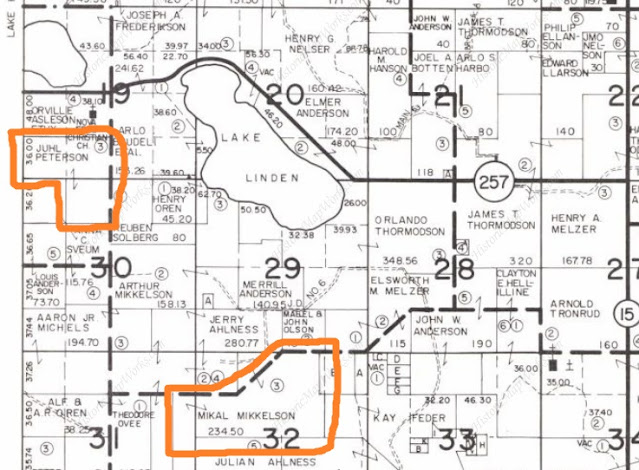
The Linden map shows that either Paul or my father Juhl has sold the 40 acres they had owned at the far left corner; perhaps it was a trade for the forty acre parcel my father now owned across the township border. In addition, Ole Syverson had sold all his land around 1930; he and his mother had moved into Hanska due to his declining health. He died in 1933 at the age of sixty. His land was owned in 1949 by Mikel Mikelson. However, there is a sixty acre property just north of the old Syverson farm owned by a Siver O Syverson. This may have been Ole’s brother Siver, another of my granduncles. He lived until 1956, so could have owned land. Perhaps Ole had shared the proceeds from the farm with his brother, enabling him to buy property of his own. The map also shows that my Linden land was owned by Hans Knuth in 1949.

The final map shows Linden Township in 1969. The main item
to note is that my father, Juhl Peterson, had bought the Knuth property following
the death of the last Knuth family member. In the 1970s, my father tore down
the house that remained on the property, and my brother and I grew cucumbers
for the Gedney pickle company on about one-third acre of the property as a way
to earn money.
It was very instructive to trace the ownership of my
ancestor’s farmland over the years through these plat maps. I enjoyed
discovering when my family acquired the two parcels I now own.
No comments:
Post a Comment